S-K Tarn Ridge 2019 by Joe Murphy
Putara to Kaitoke via the Tarn Ridge route
The Tarn Ridge route across the Tararua’s is a hybrid of its sister S-K routes; the Main Range and the
Valleys, with a unique middle section that turns left at Arete to traverse the Tarn Ridge and then Eastern range through to Mt Holdsworth. Coming in at 75km and 5200m of elevation gain, it is closer to the Main Range SK in terrain and elevation, spending close to 40km on the “top’s” of the Tararua’s.
My adventures with Tararua SK’s started in August 2019 with a most excellent day spent traversing from Putara to Kaitoke via the Valleys route. It was one of those days and runs where the feel is great from start to finish and it will stay with me for life. It most certainly stoked the fire for more adventures in the hills, and some confidence that big days were achievable.
There is a moderate ‘accessibility’ challenge with an adventure that involves getting up on the tops of the Tararua’s. Short of a helicopter, or I guess tramping into a handy hut the day prior, any time spent on the top involves a few hours of driving and at least another few hours of running to get up there. With Kyle from BSR, we recced an Arete Biv-Bannister loop, which with our starting out from Kiriwhakapapa meant a modest summit over the Blue Range to get into and more painfully back out from the Waingawa valley. The trip was a highlight with a snowy Bannister proving to be an eye opener to the terrain, and the minor route traverse back up Blue Range an awesome adventure, with stunning views from the Blue Range Hut.
The beautiful Baldy-BAP-Holdsworth loop came next. My first solo adventure, taking in the most excellent Broken Axe Pinnacles. Although they are not for the faint hearted I would very much encourage visiting, as I’ve since learnt that the sidle track is a safe means of passage if the high route isn’t to one’s liking. Then a Pukemoamo / Mitre Peak-3 Kings solo loop, which provided some excellent views and a visit to the highest peak in the Tararua’s. It also covers about 8k of the Tarn SK route and any more than that, we decided over a few beers one Tuesday evening, starts to have as much opportunity cost as just going to Putara and doing the full route. Maybe it was the beer talking!
By November I had again convinced my family to provide support logistics for another SK adventure. Agreeing to taking me up to Putara for an early start, and then return to Kaitoke later that evening or much later, all going well, to pick me back up. We set a date of December 7th and so my stalking of the weather forecast began from about 3 weeks out. About 14 days out the current weather was exceptional. Every morning seemed to provide the opportunity to gaze longingly at the (visible) Southern end of Tararua’s. The wind was low and the sky clear and I started to count to myself the number of “SK” days that were coming up and passing me by.
I contemplated options to pull a sicky from work and take a train/taxi to Putara solo, jogging the 4k from Base Camp to the park entrance for a 4am start (when you’re running 75k what’s another 4k), but each time I thought I had a workable plan sense would prevail. What do I do for dinner/breakfast/change of clothes/gear…How do I pick up a vehicle from Putara the next day, would it be safe if I left it for a week… Do I only take ultra-minimal gear…stash a bag of overnight gear somewhere …sleep at Base Camp in my bivvy bag?
During that week the family conversation went along the lines of;
Wife: “What do you feel like for tea?”, me “Putara… sorry what?” I was getting impatient. That was good, it meant I was up for it.
The long-range forecast for the week leading into the Saturday was also starting to turn sour, with high winds the main theme. Then by magic the Wednesday 10 days out, an opportunity for a lift came up from a BSR dude Roel and the chance to pull plans forward by a week. Roel was looking to head up to Putara and take on the Dundas Loop, a mere 30k/3k vert loop that takes in one of the, if not the, steepest climb section in the Tararua’s. Roel means business!
The forecast ebbed and flowed over Wednesday evening and Thursday, and on Thursday nite we were looking unlikely to head up. Then Friday morning things greatly improved, later that afternoon Roel picked me up in his charmingly characterful mid 80’s Citroen CX GTi and we were off. In hindsight having Thursday evening with things looking unlikely to go ahead meant that I got a great night’s sleep, rather than not as would be the usual case.
We had an enjoyable conversation on the drive up to Putara as we got to know each other a wee bit. As it turned out Roel has supported many SK and Northern Tararua’s adventures with logistics and had an awesome SK Valleys adventure of his own earlier in 2018. He also ate hills for breakfast, lunch and dinner. I was in awe.
Roel was first up in the morning, just after 4am, and were packed and away and standing at the Park entrance for 5am. The starry night had turned to cloud and although it was starting to brighten with the sunrise it looked thick and could mean clag on the tops. There was no wind and though would mean easier travel, it also meant potentially nothing to blow the clag away.
5am rolled around and Roel kindly provided me with some space to set off on my ‘solo unsupported’ attempt by letting me go ahead first, and he started off a couple of minutes later. I’d decided to pack a bit heavier than usual, taking extra food and clothing, and was trying out a new running pack with a large rear compartment.
Compared to my Valleys adventure, which only became daylight once I started making my way down to Roaring Stag Hut, I was only in the dark for about 30 minutes. In that ½ hour I encountered something in the forest that sounded rather big, as it went crashing away through the bush and across the river, thankfully in the other direction. Probably a deer rudely interrupted from its slumber. I’m not sure who was more frightened by the experience, probably me!
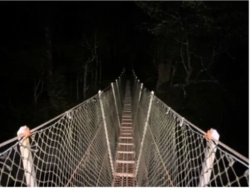
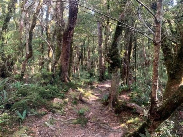
The bridge to adventure
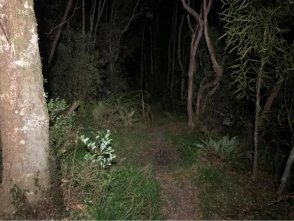
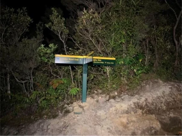
Hitting the turn off and this time taking a right to Herepai, the low cloud was set in the trees and gave the forest an enchanted feel about it, pity no goblin forests up this way. Still the Northern tracks feel much more remote and untouched.
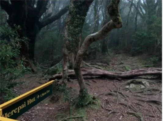
Turn right for Herepai. Mind the windfall!
All the way from here to the turn at Arete was going to be new territory for me. I had the Tarn SK GPX loaded in my ViewRanger and was mentally prepared for some route finding and nav during the first 20k. A few of the write ups from Main and Tarn SK’s mentioned some difficulties through Herepai and East to West Peaks. At least it would be an adventure.
Hitting Herepai hut at 6am and on finding the porch empty of boots, I decided to stop and check the hut out. Unfortunately for the occupants, either somebody had stolen their boots, or they had decided to store them inside, I noisily opened the door to find 5 sleeping trampers. On realising my mistake, I retreated as quietly as possible, filled water from the tank and then carried on through the high grasses and into the misty bush. From here the next planned water stop was Arete Biv, so I loaded up with 3l and headed off.
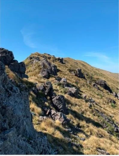
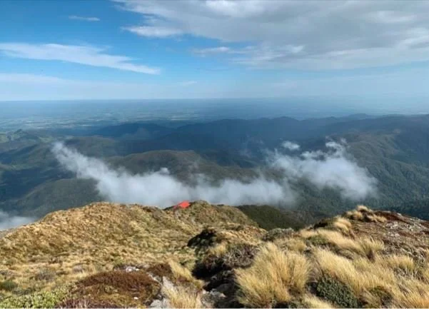
The odd lookout spot along the track was clouded out, I imagine on a fine day they would have been rather nice views.
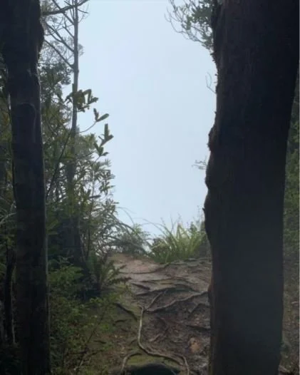
Some view!
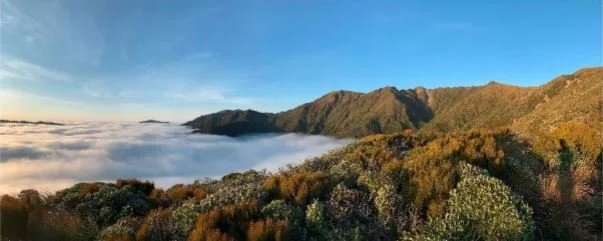
The hut sits just below the bush line and after a few minutes I started to get glimpses of blue sky and then sun, things were looking potentially rather good. That question was answered a few minutes later as I cleared the bush line to an early morning bluebird. The cloud cover stretched as far into the horizon as I could see. Absolutely epic views, and mint conditions for navigating the Northern section.
Looking South East towards Wairarapa
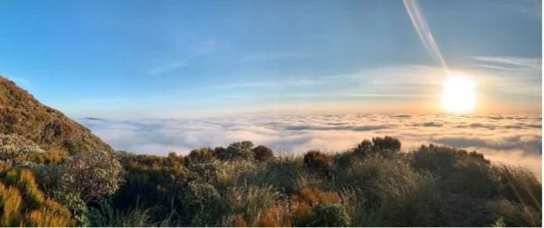
Looking North East towards Wairarapa
Up to Herepai and more epic views the fun factor was reaching a rather high 9/10. A very light SE breeze was blowing through, although it was already warm enough for t-shirts (6am).
Heading up to Ruapae I hear a Coo-e from Roel to which I respond with a rather loud Whoop, taking a moment to look back and try to spot him. No luck with the sun putting most of where I had been into shadow. Meters further up the track I spot a gas burner and a few cups of tea down on the ground. Then two hunters in camouflage stood up just over the summit of Ruapae and whisper to me they were spotting a stag lower down the ridge. One of them was particularly dark, at my whoops presumably. I offered my apologies and carried on South, half thinking I better get a move on in case they were really dark about it.
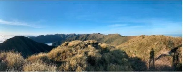
Reaching East Peak down and up to West Peak the calm day and bright sun were making the route easy to follow, I could start to see my day ahead with the peaks of Logan and Dundas becoming more clear, but still blocking most of the range further South.
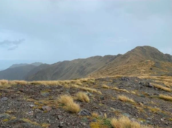
It all seems like such a long way… it is
Once up Pukemoremore the route became clearer and I could recognise Bannister and Arete in the distance, with Pukemoamo and Peggys Peak popping up behind. Appreciate the recces.
Dundas Hut turnoff with actual Mt Dundas in the foreground (right)
Once up Pukemoremore the route became clearer and I could recognise Bannister and Arete in the distance, with Pukemoamo and Peggys Peak popping up behind. Appreciate the recces.
How many climbs?
There were some awesome rocky sections pasty Dundas I felt for a fleeting moment like Legolas chasing down a pack of Orcs. Probably more an Orc chasing nothing.
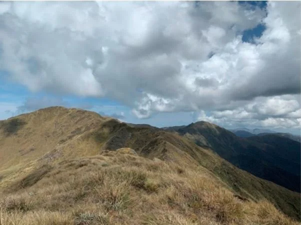
South Island? North Island?
Bannister loomed closer and closer and eventually passed when I dropped off the ridge to Arete Peak to meet up with Arete Biv lower down. As I was approaching Arete Biv I spotted a couple of deer. My advantage being down wind, and two minor spurs to duck behind, I had the opportunity to get to within about 20 meters before they heard me and the now three of them, one hidden from view initially, took off uphill to Arete Peak at full speed. I always enjoy seeing deer in the Tararua’s, an amazing sight, seeing them move so quickly across the difficult terrain.
Looking back North towards Arete Biv
I took a quick stop at Arete Biv, signing the intentions book and refilling all my water vessels. I had a rough goals of 6 hrs to Arete Biv, 12 hr to Powell Hut and then 18 to the finish and was stoked to be at Arete in 5:25hrs. Pulling my pack back on, with the added 2kg of water, it felt heavy, and so with that I carried on to Waiohine Pinnacles and Tarn Ridge.
By about 10:30am the day was really heating up. The forecast was for mostly clear sky with increasing high cloud and the potential for some rain between 2pm and 6pm. I started to wish for the rain to come a bit sooner and cool me down. Kyle and I had been through to Waiohine Pinnacles from Arete Biv but approaching from Arete Forks we hadn’t summited the rather craggy looking Waiohine Pinnacles. I was mentally preparing for a BAP experience, but the Northern approach was much easier than I expected. The Southern exit provided a bit more steepness, although it sidles most of the worst looking outcrops.
Junction on Waiohine Pinnacles with Mt Lancaster in the background
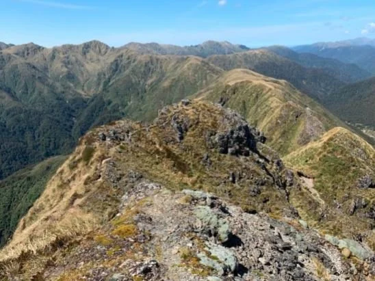
The Waiohine Pinnacles up close, looking towards Tarn Ridge leading to Girdlestone and the Eastern Range in the background
The next section was by far the hottest and at times I felt like I was starting to melt. I was thankful for the massive (for me) amounts of water I was carrying as I worked my way through about 2 ½ litres of water between Arete Biv and Tarn Ridge Hut. I put on some music to lift my spirits and
provide a little distraction from the heat, every now and then a cool breeze would pass but not enough to be of much assistance. My wishing for cloud was turning into polite demands, even bring the forward the rain by an hour or two.
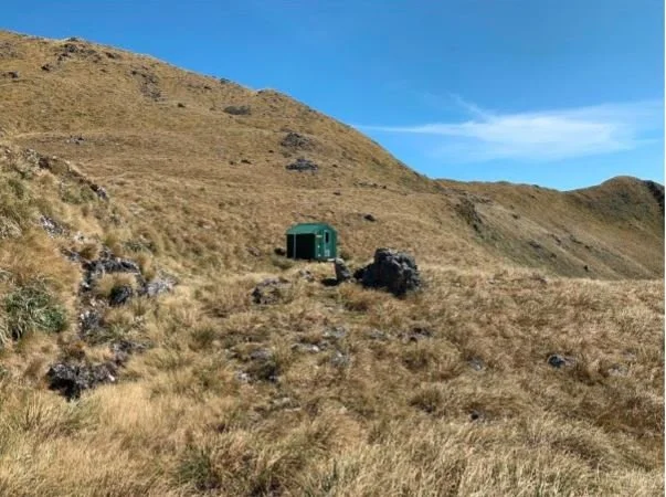
Passing Basil’s grave, hats off to Basil and a moment to ponder what it would have been like all those years ago. I arrived at Tarn Ridge Hut and took a few minutes to cool down, explore the hut and refill my water. The next water stop, all going well, would be Powell. Though mid-King Biv (out of desperation, being a fair detour) and Jumbo (although less of a detour) were options, Powell was probably 4-6 hours away and any detour would add another hour or so. I imagine it gets quite windy on Tarn Ridge, being as exposed as it is.
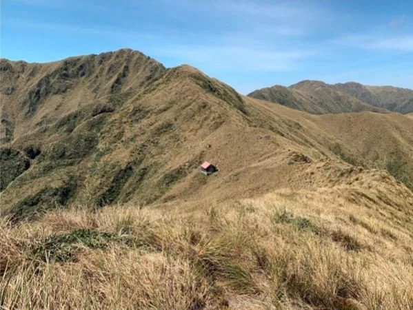
Tarn Ridge and Hut
Making my way up Girdlestone, conserving as much energy as I could in the heat, I noticed the clouds were starting to form a little lower. Good, I thought.
Past Girdlestone and still in the sun I had a chance to trot down a little towards Adkin. I hadn’t thought that the 3 Kings looked that big when I’d recced them, the perspective of them from Pukemoamo and Girdlestone makes them feel relatively smaller. Approaching from Tarn Ridge they seemed to be much bigger than I remembered. Likely the length of the day starting to wear on my mind.
Come to me clouds!
At North King, I thought I felt a drop of water on my arm but was still in sun and dismissed it as a rogue drop of sweat from my head or neck. I could see parts of the Main Range were in cloud, as was McGregor, so carried on hoping for it to cool down a bit as I got closer.
By Mid King, there were clouds building overhead and some light rain here and there, nothing to worry about as it was still a pleasant day, and I was happy not to be in the sun for a bit. By South King and then Baldy it was definitely raining, and I had the feeling that it was only raining on me as the Wairarapa out to the East was under full sun, as was the Main Range to the West. Nice to be cooling down and so I didn’t bother to pull out my rain jacket.
Yes, some relief!
Heading towards BAP the heavens opened and the rain started bucketing down. Time to act. I pulled on my jacket and zipped up with my cap under the hood to keep the rain off as much as possible. Reaching BAP, the rain was so heavy it seemed to be bouncing off the rocks and back up into my face.
Hold on a second, rain doesn’t normally do that and after stopping to take it in, it was hail that was bouncing around and rapping at my cheeks through my jacket! I stood for a second contemplating the high route but the rain and then hail had sealed the deal and I took the left to sidle BAP. I even started to contemplate bail out options if I heard any thunder, optimistically thinking that it would certainly hit somewhere else first and so pre-warn me to get off the tops ASAP.
The hail continued and once I re-joined the ridgeline it started to go back to just rain. I had certainly cooled down a bit, and though I could still see the Wairarapa in clear sun, as was the Main Range and looking back North, the rain made my pack feel about 10kg heavier than it should. My jacket had failed to withstand the amount of water and simultaneously allow my body to evaporate all the heat from moving and I was soaked through.
No wind though. Got to appreciate the wins.
The rain unfortunately didn’t make the peaks any flatter!
On past McGregor, I could see Angle Knob with Jumbo Hut glinting, and started to make out Mt Holdsworth in the distance. I passed a pair tramping a Baldy/Jumbo loop, about as wet as I was, but with proper heavy packs. I wished them well and carried on past. From then people started to pop up on the track with a group in the distance making their way down from Mt Holdsworth, and another heading up. The rain had cleared up at Jumbo and the day was coming good again.
Approach to Powell
I stopped for a bit to refuel at Powell Hut and to check my splits and was stoked again to be at Powell just ahead of 12 hrs. To counteract that, my legs were tiring, and my pack felt really heavy, so I wasn’t holding out a huge hope for an amazing second half. I sent off a few messages and the important fun factor report to Martini, Kyle and Josh. After the highs of Herepai to Arete (9/10) to the lowly 2/10 through BAP I had recovered to a solid 7/10, just enough wriggle room to take a punch in the face from Cone Saddle if needed and still get it done.
The guys were awesome as ever with their encouragement and I was starting to wholly feel that barring calamity this Tarn was going to get done. I dropped down to Totara Flats at the turn off and carried on encountering people all the way down the Totara Flats track. ‘Good jobs’, ‘nice ones’ and ‘good luck’ were exchanged as we chatted for a few seconds about our respective journeys. Arriving at Totara Flats the place was crawling with kids and groups of trampers staying over for the night.
For the most part I don’t think the overnighters at Totara Flats knew what to make of me, possibly wondering why I smelt so, or if I was the first of an onslaught of worser smelling arrivals. I chuckled to myself as I filled my water, also starting to go a little barmy as I was having conversations with some of the people in my head rather than in person. At least I think so. Skipping refilling the bladder now and left them to their evening in the hut.
The ever lovely Holdsworth - Totara Flats track (except in the rain, winter, uphill or when you’re tired)
Out on to the flats proper and my favourite place in the Tararua’s. There were loads of tents set up as a tent village in the grassy stands of Manuka, a great idea I must do in the future, and an irregular procession of people heading in for the night. Some in sneakers, jeans and t-shirts carrying just a sleeping bag (!), others with big heavy packs. Although my pack never really stopped feeling heavy, I could appreciate their load would be much more difficult.
Not sure I’ll ever get tired of the view – Totara Flats looking towards Pig Flats and Mt Holdsworth in the background
My legs had carried on slowly wearing out, and my pace dropped a bit from Little Totara Flats to walking the ups and shuffling the flats and downs. Probably the internal governor preparing for the upcoming Cone Saddle, which as always provides me with much anticipation.
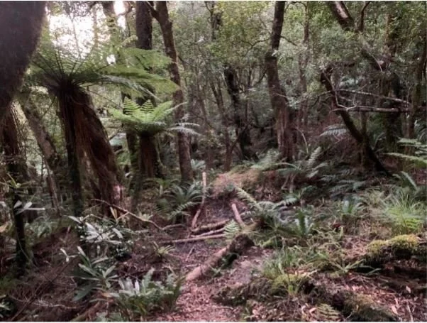
The lovely Cone Saddle track
Cone Saddle was much dryer than previous times I had been through, and for the first time was successfully navigated without going off course. I proudly didn’t check ViewRanger (are we there yet) and patiently waited for the ascent to reach its peak, hook right and on to the clearer path that leads down to the second saddle, then over and down into Tauherenikau. By now it was getting dark and so at the intersection I pulled out my head torch and then continued with the morning theme bumping in to sleeping deer, with them frightening the heck out of me as much as I did them. Thankfully it was still them that crashed away through the bush and not me. This must have happened 5 or 6 times down in to Cone Hut.
I dropped down the track into Cone Hut in full darkness by now and for the second time in one day, due to the lack of activity around the Hut I mistakenly assumed nobody was in. As it turns out, three people were sitting on the porch of the hut enjoying the darkness and I subsequently obliged by interrupting their peace and blinding them with my head torch. They were nice enough about it as we chatted about each other’s day and I refilled my water for the last time. They seemed pleased to see me but were probably more pleased to see me leave.
Out on to the Tauherenikau River track and the odd fire and camp site came and went, it must have been an odd side, a bright light trotting along the track, appearing, passing and disappearing with no explanation.
Tiredness had continued to win its battle over my eagerness to make progress and I started alternating shuffle and walking the flats and shuffling the downs, just that there aren’t many downs in the Tauherenikau valley. My mental state was still good. There was no way this mission was not going to reach Kaitoke sub 24 hours, I’d crawl out if necessary.
The Tutuwai Hut sign came and went, thankfully that I’d been through here enough times now to beable to follow the track even in dark. The white flowers of the slip, the possum forests and eventually the forested ups and downs before the bridge and then the bridge itself.
The seemingly never-ending Tauherenikau track
After the bridge came the memorial cricket wicket, Smith’s Creek Shelter, Dobson and then it’s around an hour of travel time up and over the Puffer Saddle, and in to Kaitoke. The end was nearing and not soon enough I was starting to think.
The Puffer was nice in that I could stop badgering myself to run and settled into a fast hike up the gentle slopes. A few more deer inadvertently disturbed, by this stage I was getting used to it and so chuckled to myself that it might be worth one of them running at me so that I could get through a wee bit faster. Thankfully that never happened. Past the first, second, third and fourth creek crossings and then finally the Puffer track proper starts, also signified by some lovely gorse as a departing gift from the Tararua’s. As if it were saying “Come back soon. Here’s a something to take with you to remember me by.” Thanks, just what I needed.
The track up to the Saddle always gives me a bit of a pick me up as the air clears up a bit and the summit provides views of the lights of Kaitoke and SH2 which also signify civilisation and home. My phone also started to ding with messages from Martini and Kyle, more awesome encouragement sent hours earlier, also from my good wife telling me she was at the carpark waiting.
The way to Marchant
My pace picked up with the downhills and my spirits continued lifting as familiar landmarks that signify the end continued to pop up; The creek where we drank from leaf cups one time. The 800m to go sign, also showing the way to Marchant.. next time my friend. The slippery clay, not slippery this time. The steps, not full of water or muddy for a change. The cable park and then yessss… the carpark and some shared whoops with my wife welcoming me to the finish.
Putara to Kaitoke via the Tarn Ridge route was done. I was done too.
We stood in the carpark sharing the finish, my wife pondering what to do with a somewhat stinky husband, and me slowly adjusting from the incessant desire to keep moving to working out how to finally stop without crashing completely. In the end I just hopped in the passenger seat, put the seat back and crashed out anyway, telling my wife the usual “I’m done with running” lines that lasts all of about 12 hours.
The views, the heat, peaks and climbing, the rain, more peaks, deer, the beauty and the difficultly, the valleys and saddles and the tiredness. What an adventure.
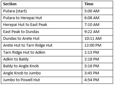
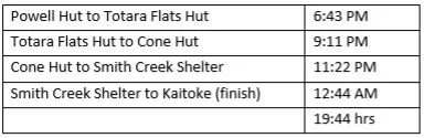
My Tarn SK finished in 19:44:16.
Joe
Doing this has given me a huge appreciation of the epic Tarn SK adventures that have come before mine. Winter icy traverses. 17 ½ hour speed missions. Epic beat the clock, miss the clock and bail out altogether adventures. Well done all of you. You have my upmost respect for even taking those first few steps from Putara irrespective of the ending.
Thanks and my appreciation go to the BSR crew, especially to Roel who not only kindly drove me up to Putara, but then went on to conquer his own epic adventure tackling the Dundas-Cattle Ridge loop. No mean feat! Thanks so much Roel. Thanks also to Martini for his ever-constant encouragement and to Kyle and Josh for the same, and the recces and missions and good times.
Thanks again to everyone who has written up their SK reports and shared their adventures. Even though I’ve been on some of them now too, I still read them. Some are in their third of fourth reading and they continue to provide me with inspiration and the motivation to get out there and do it.
Stuff taken:
18 x gels (12 used)
3 x 500ml water flasks + 1.5l bladder (refilled along the way to total 6.5l water)
5 x Avocado filled Croissants (2 eaten)
Big bag salted cashews (1/2 eaten)
6 x energy muesli bars (2 eaten)
Couple of “Le Snacks” (not touched)
Couple of Snickers and Peanut Slabs (not touched)
Salomon Skin Pro 15L running pack
Waterproof jacket and pants
Polyprop gloves + waterproof liners
Wool arm warmers + Thir
Head torch and spare batteries
PBL, Phone + ViewRanger
Fenix 5X+ watch
Topo map and compass
Emergency food (4 gels, 2 muesli bars, 2 sachets tail-wind powder)
Emergency clothes in a dry bag (polyprop top/pants, spare socks, thir, gloves and t-shirt) • Emergency survival bag + Bivvy Bag
The numbers:
By Joe Murphy